Drone-supported hazard and risk analysis
Authors:
Georg Heim, DRR-Advisor Swiss Red Cross
Andrea Blindenbacher, Technical Manager sensefly.com
Carlos Montes, Programm Director Honduran Red Cross
Generation of aerial imagery and 3D-Terrain Models to determine hazard prone areas and monitor project progress.
In the night of 28.9.2008 a mudslide affected the village of Avispa in the northeast of Honduras. It destroyed several residential buildings. A total of nine people died. This catastrophe was triggered by a tropical thunderstorm which caused a landslide that clogged the nearby torrent above the village with sediments. Shortly afterwards, the backwater broke loose and formed the devastating mudslide.
Today, 12 years later, the population of Avispa has increased. Because of the proximity to the watercourse and the roadway, the flat areas near the Avispa torrent are preferred settlement areas. But are these areas safe from future flooding? Could events such as those that occurred in 2008 happen again and would the damage areas be identical to those of 12 years ago?
In May 2019, a team of the Honduran Red Cross, managed by Carlos Montes, investigated these issues as well as the need for structural protection measures. Together with villagers, he reconstructed the event in 2008 in order to draw analogies for future events. The analysis of landslide cracks and deposits in geologically comparable areas of the region was also helpful. This revealed that unwooded slopes steeper than 22° are generally susceptible to landslides and can clog up adjacent watercourses.
The Honduran Red Cross has used modern drone technology to localize slopes susceptible to landslides and to demarcate flooding prone areas in the village of Avispa. The Swiss company senseFly SA (www.sensefly.com) has provided a fixed-wing drone for this purpose. A laptop was used to determine the flight route in the terrain, after which the drone flew over the area autonomously
Video showing the start of the fixed-wing drone Ebee X.
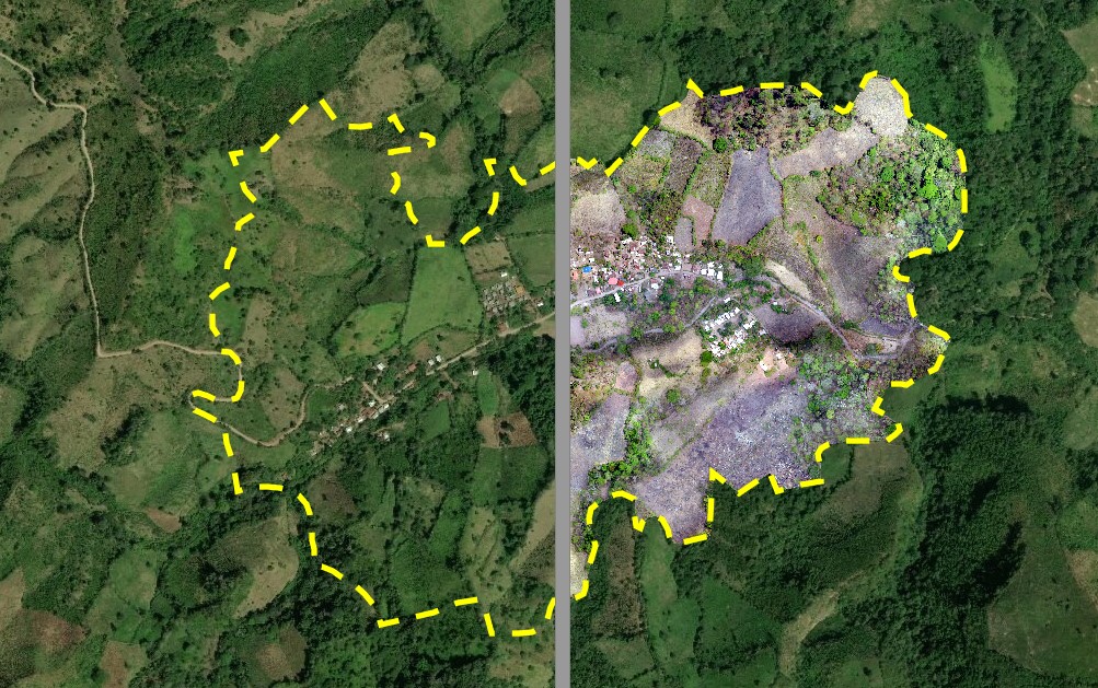
The senseFly drone generated a current, high-resolution aerial image of Avispa. >click on the picture for image animation.
Another product from the drone flight was a 3-dimensional Terrain Model.
Based on the 3D Terrain Model, all areas with a slope steeper than 22° could be delineated and displayed in a GIS (Geographic Information System). This made the process of defining areas prone to landslide hazards near the Avispa torrent fast, easy and accurate. The 3D model was also used to model a possible mudslide as shown in the next figure.
The model shows that during an extreme event, a total of 53 buildings could be affected by floods and mudslides flowing through the Avispa torrent. The hazard level was defined based on the return period and the intensity of future events.

The hazard map is an important basis for planning structural protection measures. Together with the high-resolution aerial photograph in the background, the hazard map is also used by the population and local authorities for urban planning.
The use of drones is particularly suitable in areas that are hard to access and no suitable nor current map data is available. This technology is, like any other, also subject to limitations induced by regulations, weather or drone specific requirements, which can’t be served well in certain conditions. The cost-benefit ratio and ease of use of such technology makes it an valuable asset and important tool in the data collection process for hazard and risk analyses or any environmental monitoring.
What you need to use drone technologies
If you want to use drones to monitor project progress, the requirements are low. A drone pilot training of a few hours is sufficient to independently perform drone flights and download the photos to your computer. The creation of digital 3D elevation models requires a training of 1 to 2 days and the purchase of an appropriate software (e.g. Pix4D mapper). The company Pix4D offers corresponding technical instructions on their website www.pix4D.com. Experience in the use of GIS is recommended. For newcomers, appropriate knowledge can be acquired in a course of about 1 week. On the net you can find several e-learning courses for ArcGIS or QGIS.


