Acquisition of satellite-based meteorological data
Authors:
Georg Heim, DRR-Advisor at Swiss Red Cross
Claudia Röösli, Head of NPOC, University of Zurich
Vladimir Vingate, Postdoctoral Researcher at University of Zurich
Generation of meteorologic data such as precipitation, temperature and soil moisture in remote areas without ground measuring stations.
The idyllic setting of the hamlet of Los Amates is misleading. Close to the Los Amates stream, less than two hours by car from the hustle and bustle of the Honduran town of Choluteca, there are 15 residential houses, a church and a corner shop. Contrary to the tranquillity of the hamlet, the annual concern about flooding is evident when discussing with the residents. In the last 25 years, the residents have experienced four devastating flood events, which have partially or completely destroyed their homes and livelihoods. Every year, during the rainy season, residents follow the rising water level with concern, and hope that the water does not reach their houses.
The Honduran Red Cross has assured the population of Los Amates of its support in the planning of a flood protection dam. Precise dimensioning of the dam is crucial: in fact, a too small and too short dam can increase the risk of flooding, while a too high and too long dam can jeopardise its financial viability. Therefore, to ensure that the dam is built with the correct dimensions, reliable data on historical precipitation is required to predict future flooding in terms of frequency and magnitude.
Although weather stations are not present in these areas, climate data can be obtained retrospectively using meteorological satellite data back to 1981. A vast number of such satellites orbit the Earth around the clock and record meteorological data such as precipitation, temperature and soil moisture. These series of measurements are compiled by various operators and made freely available globally. This allows, for example, to retrospectively measure the daily totals of precipitation over the last four decades.

The National Point of Contact (www.npoc.ch) for Satellite Images’ scientific consulting service is situated at the University of Zurich and is a public service of the Swiss State Secretariat for Education and Research. It supports Swiss authorities, research institutions, organisations and commercial service providers in the use of satellite data. As part of its collaboration with the Honduran Red Cross, the Swiss Red Cross contacted the NPOC with the request of support to achieve satellite-based meteorological data for the planning of the flood protection dam for Los Amates.
An initial exchange with NPOC has shown that the Google Earth Engine (GEE) allows to access satellite-based data, including images and meteorological data, that are freely available. Furthermore, the engine is very powerful in performing calculation of large data set such as from time-series and allows to export the results afterwards.
With the support of the NPOC, an application has been developed in GEE to export daily precipitation totals anywhere around the globe as an Excel data set. The big advantage of this application is that the user can independently define any point of interest on Earth, and extract meteorological data from the underlying data set. No previous knowledge is required to access the data. Instructions for using the application can be found in Annex 3 at https://ghr.redcross-intern.ch/en/?p=threat.
Using GEE, the daily totals of precipitation in the Los Amates catchment could be recorded retrospectively over four decades. By means of a statistical evaluation, the frequency of occurrence of extreme precipitation events could be determined. Then, taking into account the hydrological and topographic conditions in the catchment area of the Los Amates stream, the flood runoff amounts for future events with different return periods could be computed. These discharge values were used to calculate the river water levels, and thus served as a basis for determining the size of the flood protection dam. Tools for the hydrological and hydraulic calculations can be found using the following link: https://ghr.redcross-intern.ch.
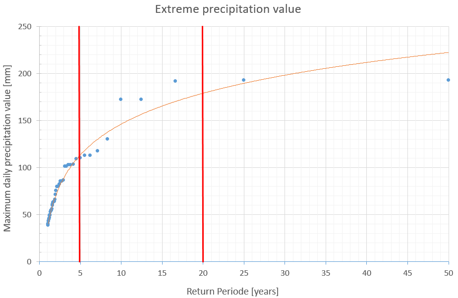
Extreme precipitation values for return periods of 5 and 20 years in the Los Amates catchment. ©SRC
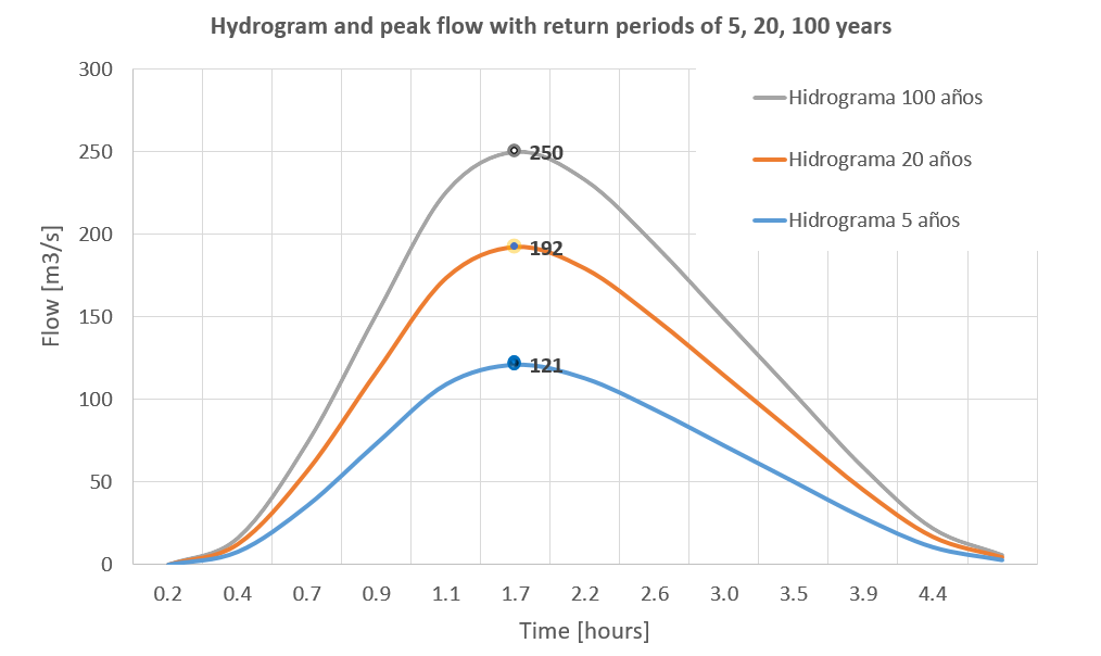
Runoff hydrograph with peak flow indication for the Los Amates stream. ©SRC
With regards to the quality of satellite data, in principle, satellite-based precipitation data sets have a global coverage and are characterised by a certain spatial and temporal resolution. In practice, this means for instance that localized, short-term strong rain events from thunderstorms are sometimes incompletely recorded. Particularly in mountainous regions, the averaged values can deviate from total precipitation values. In order to capture the limitation and inaccuracies of the satellite data, a quality analysis is recommended by comparing these data sets with ground measurements taken from the area with the nearest measuring station.
Based on the defined water levels of future flooding events, the local engineer is currently planning the protective dam. The cost-benefit analyses also carried out attest the measure a high cost-effectiveness. The residents of Los Amates will thus soon have the urgently needed flood protection.


